

Published on: 08/22/2025

Description
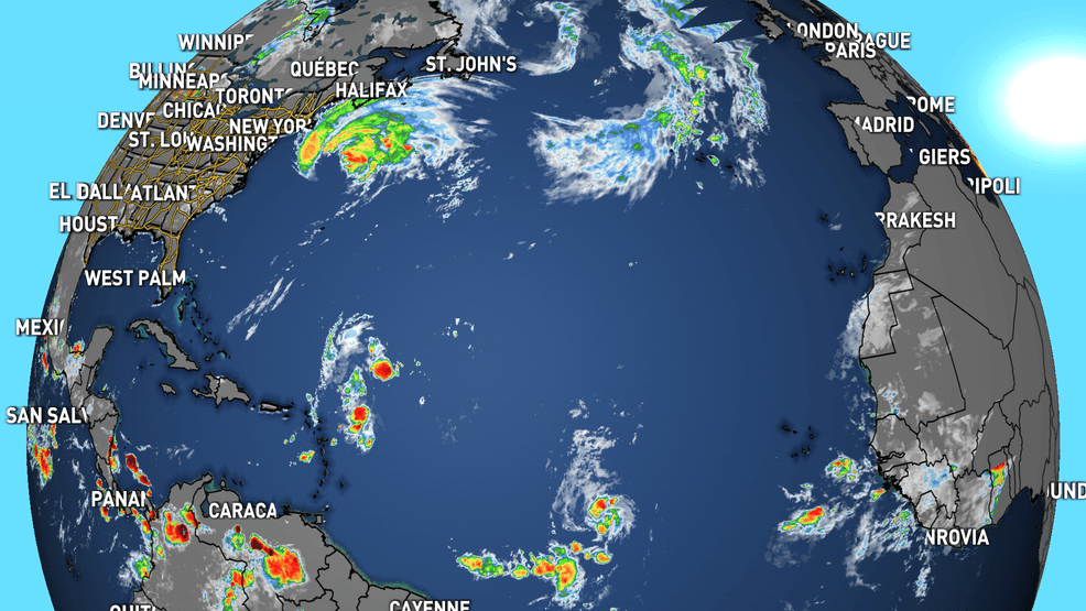
Hurricane Erin continues to move away from the United States and into cooler waters of the northern Atlantic.
The storm is forecast to become a post-tropical system by the start of the weekend as it moves northeast.
All coastal watches and warnings are no longer in effect.
Swells generated by Erin will affect the Bahamas, Bermuda, the east coast of the United States, and Atlantic Canada during the next several days. These rough ocean conditions are expected to cause life-threatening surf and rip currents.
Invest 90L
A tropical wave located a couple hundred miles east-northeast of the Leeward Islands continues to produce disorganized showers and thunderstorms.
According to Friday morning's Tropical Weather Outlook issued by the National Hurricane Center, or NHC, environmental conditions appear conducive for further development of this system, and a tropical depression is likely to form this weekend while it moves northwestward and then northward, in between the Lesser Antilles and Bermuda.
This system will take a similar path to Hurricane Erin and will remain off the east coast of the United States. There is no threat to South Florida.
Invest 99L
Another tropical wave in the central Atlantic is producing organized showers and thunderstorms. According to the NHC, this system could become a tropical depression at any time, but the latest satellite-derived wind data indicate that the system does not have a well-defined circulation center.
The system is expected to move into a less conducive environment later today through Saturday but could reach a slightly more favorable environment again late this weekend into early next week as it moves westward at 10 to 15 mph over the central tropical Atlantic and approaches the Lesser Antilles.
Central Subtropical Atlantic
A small low-pressure area in the central Atlantic is moving into a region of dry air and will limit further development. This system is forecast to dissipate this weekend as it remains stationary.
Other Related News

08/23/2025
ALBANY Ga WALB - With an action-packed week in SWGA high school football there was still s...
08/23/2025
DOUGHERTY COUNTY Ga WALB - For the first time since the murder trial of Evelyn Odom began ...
08/23/2025
BAINBRIDGE Ga WALB - An emergency closure order was issued Friday for Little Blessings Chi...
08/23/2025
PEARSON Ga WALB -The City of Pearson water sample results are in and the boil water adviso...
08/23/2025
ATLANTA Ga Atlanta News First - The mother at the center of an Amber Alert out of Florida ...
Follow

Download Our App


Copyright 2022 © Albany Metro Community. All Rights Reserved